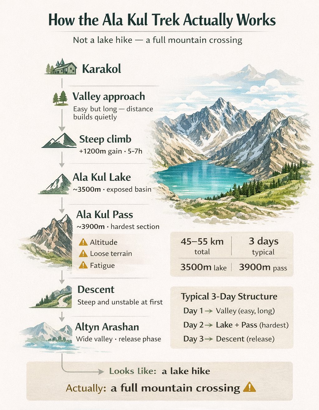
Ala Kul Lake in Kyrgyzstan: How the Trek Actually Works
Ala Kul shows up early in most Kyrgyzstan travel plans. A bright alpine lake somewhere above Karakol, a name that keeps repeating itself across itineraries, photos, route suggestions. It looks straightforward at first — a point on a map, high in the mountains, something you go to and come back from.
That idea doesn’t really hold once you get closer.
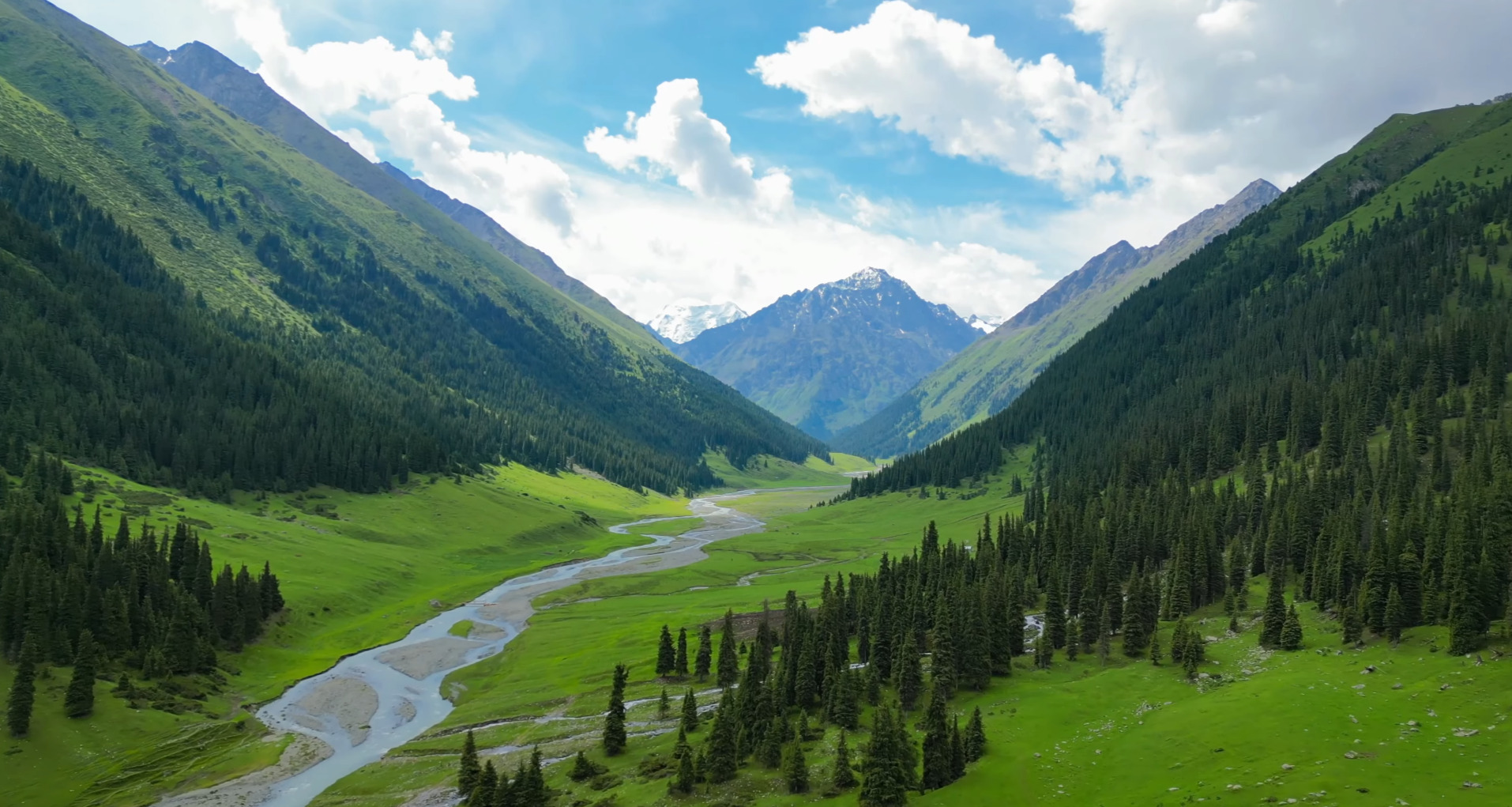
You don’t arrive at Ala Kul the way you arrive at a viewpoint. The route pulls you inward first. Forest, then a narrowing valley, then ground that starts to tilt just enough that you notice your breathing change. The lake sits high enough that by the time you see it properly, you’ve already been moving through a different version of the landscape for hours.
And even then, it’s not the end of anything.
Above the lake, there’s a pass — the part most people underestimate when they’re still looking at photos. That crossing shifts the entire experience. What looked like a destination turns into a transition. What felt like a hike becomes something closer to a route.
That’s why Ala Kul stays with people. Not just because of how it looks, but because of how it unfolds — and how it doesn’t really work as a single stop.
- Start: Karakol Valley (forest + gradual ascent)
- Midpoint: Ala Kul Lake (~3500m)
- Key challenge: Ala Kul Pass (~3900m)
- Exit: Altyn Arashan (valley + hot springs)
- Best format: 3-day crossing (not a return hike)
Why Ala Kul Matters
There are plenty of mountain lakes in Kyrgyzstan. You’ll pass smaller ones on other routes, see others from a distance, even camp beside a few without planning your entire trip around them.
Ala Kul isn’t like that.
It sits in a position that forces you to move through the landscape in a very specific way. You don’t reach it casually. You commit to the valley, gain elevation steadily, and eventually step into terrain where altitude, exposure, and weather start to matter more than distance.
And then, just when it feels like you’ve reached the point everything was building toward, the route keeps going.
That structure — approach, climb, lake, pass, descent — is what makes Ala Kul one of the defining mountain routes near Karakol. Not because any single part is unique on its own, but because all of them sit tightly together inside a relatively short distance.
Within a few days, you move through forest, alpine terrain, high-altitude lake conditions, and a full pass crossing before dropping into a completely different valley system. That kind of compression is rare. It’s also what makes the experience feel more complete than it looks on paper.
This is also why Ala Kul almost never stands alone in real travel plans.
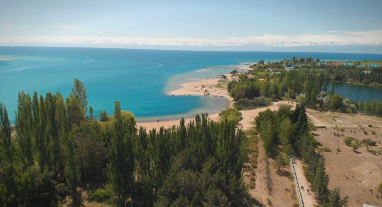
Look closely at how people move through this part of Kyrgyzstan and you’ll notice the same pattern repeating. Karakol as the entry point. A climb through the valley. The lake somewhere above. The pass. And then, on the far side, Altyn Arashan — a softer valley, open ground, hot springs, and a sense that the route has resolved into something else.
It’s not two separate destinations. It’s one continuous movement.
That’s the part that doesn’t show up clearly in photos. But once you’re on the ground, it becomes obvious pretty quickly.
Ala Kul at a Glance
| Feature | Ala Kul Basics |
|---|---|
| Location | Mountains above Karakol, Issyk-Kul region (Terskey Ala-Too range) |
| Lake elevation | Approx. 3500–3560 meters |
| Pass elevation | Approx. 3800–3900+ meters |
| Route length | Roughly 45–55 km depending on variation |
| Typical duration | 2–4 days (3 days most common) |
| Route type | Point-to-point mountain crossing |
| Main challenge | Altitude, steep ascent, pass crossing, changing weather |
| Best season | Mid-June to mid-September |
| Why people do it | High-altitude lake, pass crossing, connection to Altyn Arashan |
Those numbers help, but they don’t fully explain what the route feels like.
The distance isn’t extreme. The timeline isn’t unusual for a multi-day hike. On paper, it can even look manageable if you’ve done other mountain routes before.
What changes things is how those elements stack together.
You gain altitude quickly enough that it stays noticeable. The most demanding section lines up with the most important part of the route. And the highest point — the pass — doesn’t sit at the beginning or the end, but right in the middle of the experience.
That combination shifts the way the trek feels in practice. It stops being a sequence of easy segments and starts behaving like a continuous build toward a single crossing.
Ala Kul on the Map
From Karakol, the route doesn’t spread out. It funnels inward.
You move into Karakol Valley first — a wide, forested corridor that gradually narrows as you follow the river upstream. Early on, it still feels connected to the town. There are signs of access, movement, occasional traffic depending on where you start.
That sense fades as you go higher.
The valley tightens. The trees thin out. The terrain becomes more exposed, and the path starts to feel less like a walk through a landscape and more like a path carved into it.
Ala Kul sits above that transition, tucked into the upper basin below the pass. It’s not visible from below. You reach it only after committing to the climb.
Above the lake, the route continues toward Ala Kul Pass. That’s the point where the direction of travel matters. One side still belongs to Karakol Valley. The other side opens toward Altyn Arashan.
Once you cross, the structure of the route changes again.
The descent pulls you into a different system entirely — broader, softer in places, but still high enough to remind you that you haven’t fully left the mountains yet. Eventually, the terrain opens into Altyn Arashan, where the route slows down again and starts to feel less compressed.
Seen like that, Ala Kul isn’t a destination in the middle of nowhere. It’s a link between two distinct mountain spaces.
If you imagine Ala Kul as a point, it feels remote and disconnected. If you imagine it as a crossing between Karakol Valley and Altyn Arashan, the route becomes much easier to understand.
Where Is Ala Kul and How the Region Is Structured
On a map, it looks almost too simple. Karakol sits right at the edge of Issyk-Kul. The mountains rise immediately behind it. And somewhere in that mass — Ala Kul.
What the map doesn’t show very well is how that distance actually unfolds.
You don’t step out of Karakol and suddenly feel like you’re in high mountains. It shifts in layers. The edge of town fades, the road narrows, then you enter the valley properly — and for a while, it still feels open, almost relaxed.
Karakol Valley stretches out longer than people expect. A wide corridor at first, with the river running through it, forest on both sides, the kind of terrain where you can walk for hours without feeling like you’ve really “started” yet.
Then something changes.
Not sharply. Just enough. The valley tightens. The slope edges closer. The trail stops feeling flat. You don’t always notice the exact moment it happens, but your pace adjusts before you think about it.
This is where the route begins to pull inward.
Ala Kul sits somewhere above this transition — not visible, not obvious, not something you can orient yourself toward from below. You move into it without seeing it first. The lake only reveals itself once you’ve already committed to the climb.
And even then, it doesn’t behave like an endpoint.
Above the lake, the terrain continues to rise toward Ala Kul Pass. That’s the dividing line. One side still belongs to Karakol Valley. The other opens out toward Altyn Arashan — a completely different structure of landscape.
The shift is noticeable almost immediately after the crossing.
The descent doesn’t feel like a return. It feels like entering a new system. The space opens differently, the valley widens in places, and the movement becomes less compressed after the intensity of the climb and the pass.
Seen like this, Ala Kul isn’t isolated at all. It sits right at the hinge point between two mountain spaces — one you enter gradually, and one you drop into after the crossing.
It’s easier to understand Ala Kul if you stop thinking of it as a destination. It works better as the middle point of a crossing — Karakol Valley on one side, Altyn Arashan on the other.
Ala Kul Facts That Actually Matter
Most guides list the basics — elevation, size, coordinates — and move on. With Ala Kul, those details carry more weight than they seem to at first.
The lake sits at roughly 3500 to 3560 meters. That’s already high enough to change how your body behaves, even if you don’t frame it in those terms. Breathing becomes slightly uneven. Your rhythm breaks more often. You pause without always planning to.
And the route doesn’t stop there.
The pass above the lake rises another few hundred meters, usually somewhere in the 3800 to 3900 range depending on how it’s measured. On paper, that difference looks manageable. On the ground, it lands differently — especially because it comes after a sustained climb rather than at the start of a fresh day.
The lake itself doesn’t soften the experience.
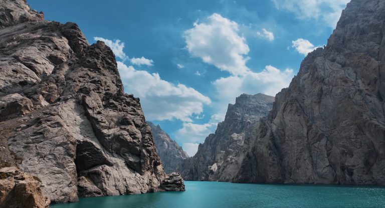
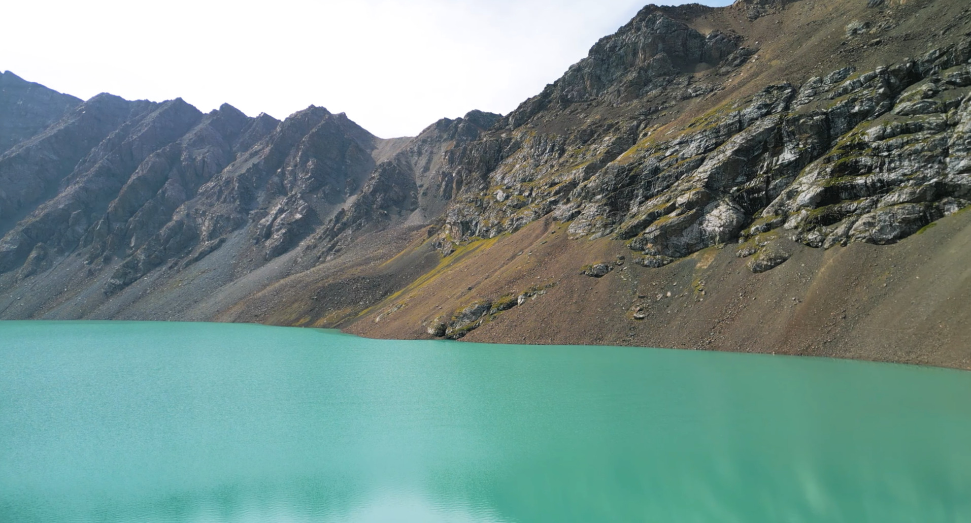
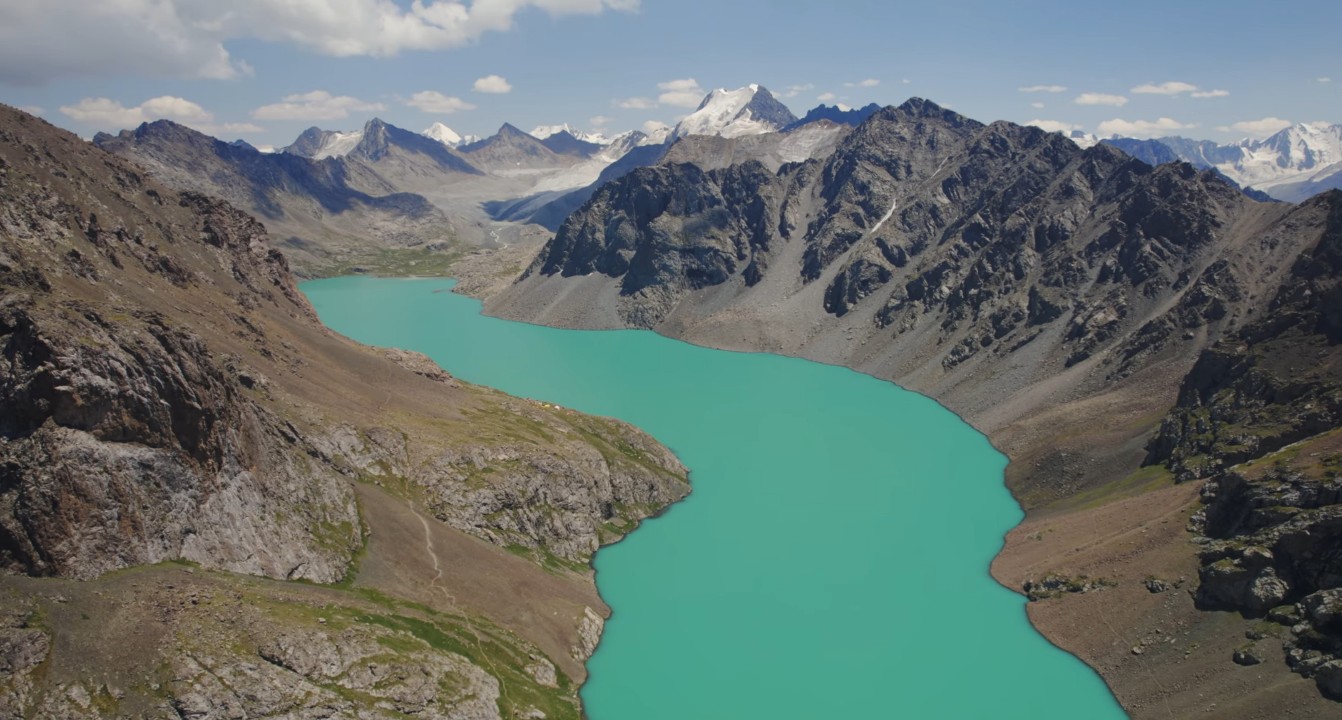
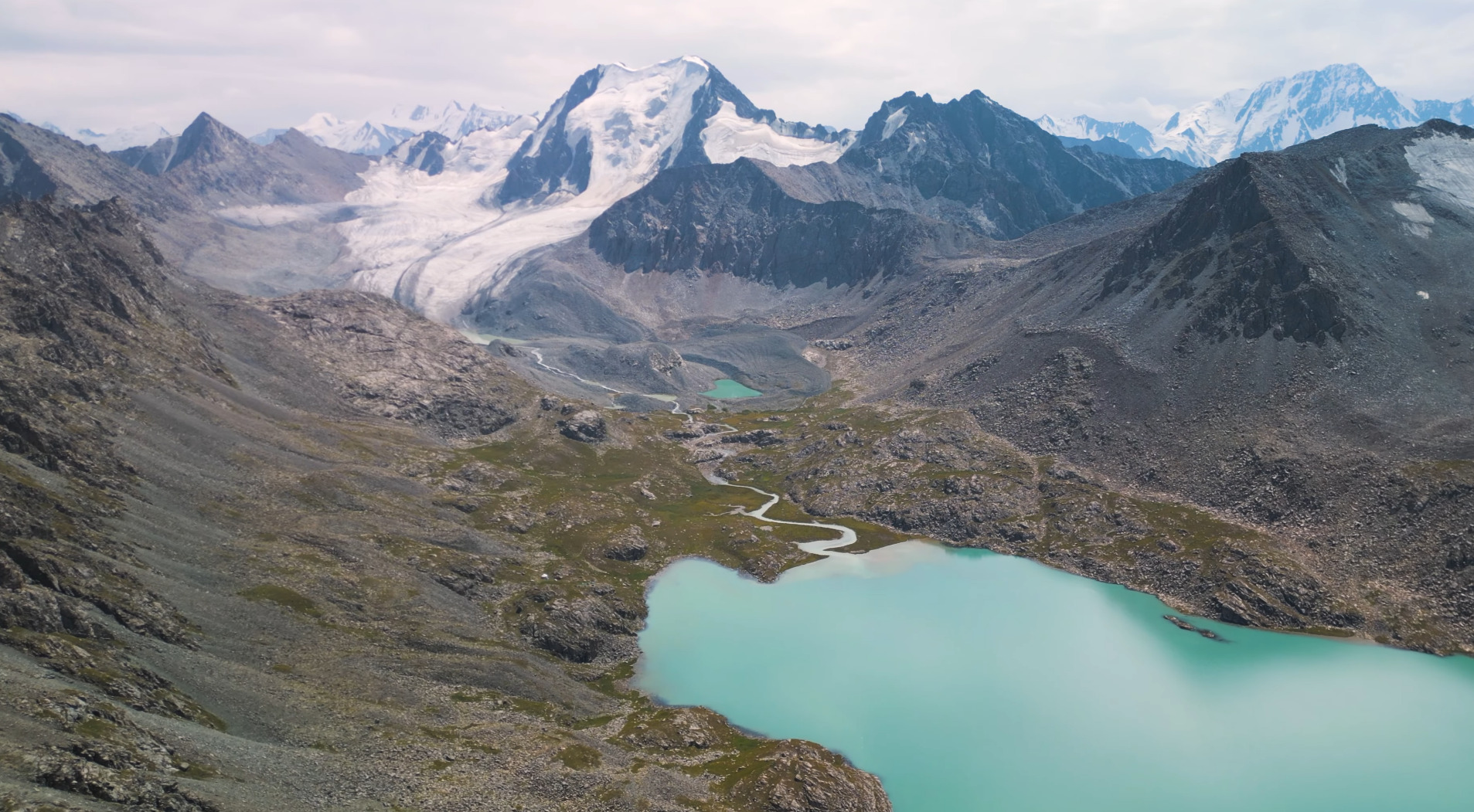
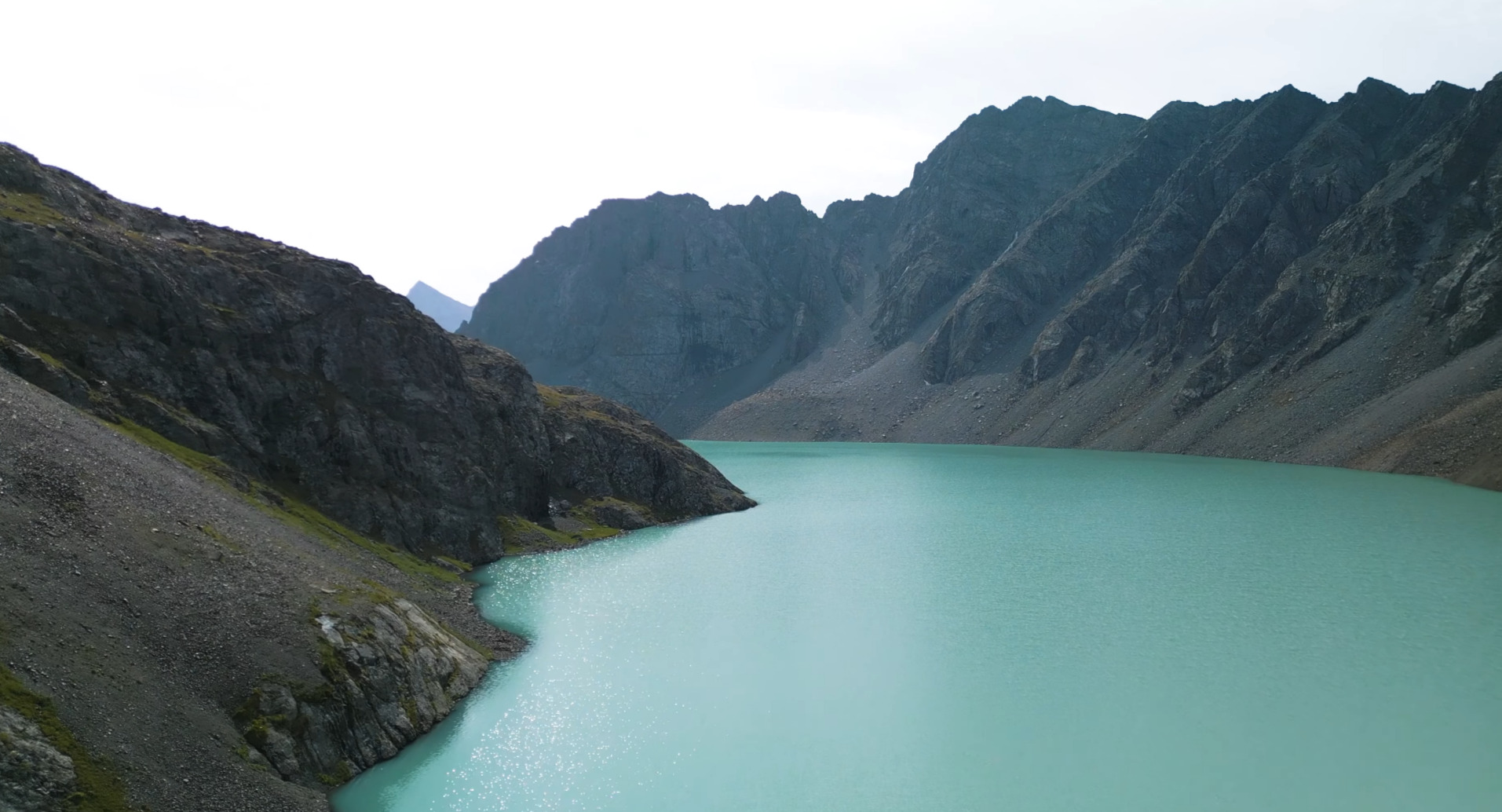
Ala Kul isn’t the kind of place where you walk down to a smooth shoreline and settle in. It sits inside a rocky basin, held in place by steep slopes and uneven ground. The edges aren’t always easy to approach, and the space around it feels exposed in a way that lower alpine lakes often don’t.
The color is what people remember first.
That sharp turquoise — almost too saturated to look real in certain light — comes from glacial sediment suspended in the water. Fine particles carried down from the surrounding ice scatter light differently, which is why the lake shifts between deep blue, green, and that almost artificial-looking turquoise depending on the angle and the weather.
It changes quickly, too.
Cloud cover, wind, even the time of day — all of it affects how the surface looks. The same lake can feel muted and heavy one moment, then suddenly bright and reflective the next without anything obvious happening around you.
The name reflects that instability in a quiet way.
“Ala Kul” is often translated as something close to “motley” or “variegated lake” — not one fixed color, but a shifting one. It’s a small detail, but once you’ve seen the lake under different conditions, it makes sense.
None of this turns the lake into a technical challenge on its own.
But combined with the altitude, the terrain around it, and the fact that it sits directly below a major pass, it becomes clear that Ala Kul isn’t just a scenic stop along the way. It’s embedded in a much more demanding section of the route.
How the Trek Actually Works
The easiest way to misunderstand Ala Kul is to treat it like a destination with a trail leading up to it.
In reality, the route behaves more like a sequence that keeps tightening as you move through it. Each section shifts slightly — not enough to feel dramatic on its own, but enough that by the time you reach the lake, you’ve already passed through several different versions of the landscape.
That progression matters more than the distance.
The route doesn’t build in one clean line. It builds in layers — approach, climb, exposure, then the pass. And the most important point doesn’t sit at the end. It sits inside that sequence.
Starting from Karakol
Everything begins with Karakol, but the transition out of town is softer than people expect.
There’s no sharp boundary where “the trek starts.” You move gradually — road, edge of settlement, then into the valley. For a while, it still feels accessible, almost too easy compared to what you’ve probably read beforehand.
This is where people tend to misread the route.
The early stretch doesn’t test anything yet. It just carries you inward.
The Valley Approach
The valley holds you in a steady rhythm at first.
Forest on both sides, the river always close, a trail that doesn’t demand much attention. You can walk here without thinking too much about effort or altitude. It feels like a long approach rather than a climb.
That’s exactly what it is.
The distance builds quietly in this section. You cover ground without gaining much visually, which creates a strange effect — you’re moving for hours, but it still feels like the route hasn’t really begun.
Then the valley starts to narrow.
The trees thin out. The river becomes louder, closer. The trail tilts just enough that you begin adjusting your pace without noticing why. Nothing dramatic happens — it’s just less forgiving than it was before.
This is where the route begins to shift from movement into effort.
The Climb Toward the Lake
At some point, the valley stops feeling like a corridor and starts feeling like a slope.
The climb isn’t a single steep wall. It comes in sections — uneven, sometimes broken by flatter stretches, but always trending upward. The altitude starts to sit in the background, not overwhelming, but persistent.
You notice it in small ways first.
Breathing doesn’t quite settle. Stops become more frequent. The idea of pushing through without pausing fades pretty quickly. The route is still manageable, but it no longer feels neutral.
This is where expectations usually adjust.
What looked like a moderate hike from below begins to feel heavier, not because the terrain is extreme, but because everything — incline, altitude, duration — starts to stack.
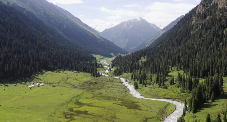
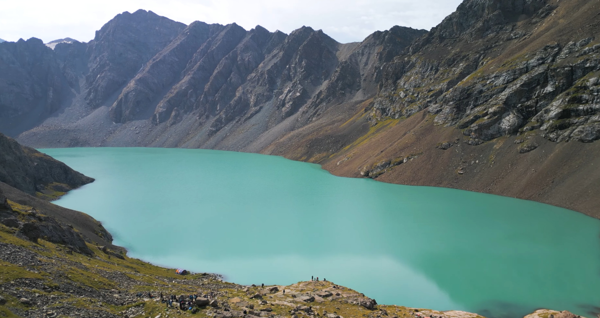
The Lake Zone
Ala Kul doesn’t reveal itself gradually.
You reach it almost all at once. One moment the terrain still feels enclosed, and then suddenly the space opens and the lake is there — flat, bright, sitting in a basin that feels more exposed than anything you’ve walked through so far.
It’s quieter up here in a different way.
Less movement in the landscape, less sense of flow. The valley below is gone, and what replaces it is more static, more defined by rock and elevation than by direction.
This is usually where people pause the longest.
Not just because of the view, but because the route finally catches up with the expectation. You’ve been moving toward something without seeing it clearly — and now it’s in front of you.
It feels like a natural endpoint.
It isn’t.
Crossing Ala Kul Pass
The route continues upward from the lake, and this is where it changes character again.
The ground becomes looser in places. The incline sharper. The movement more deliberate. You’re no longer just walking forward — you’re managing each step more carefully, especially as the elevation peaks.
The pass sits just above the lake, but it doesn’t feel close.
Distance compresses strangely at this altitude. What looks near can take longer than expected, and the effort doesn’t distribute evenly. It gathers toward the end of the climb.
This is the point where the route stops being forgiving.
Altitude, fatigue, and terrain all meet here. Even in good conditions, it demands attention. In worse conditions — wind, cold, unstable footing — it becomes the part of the trek that defines the entire experience.
Reaching the top doesn’t feel like a finish.
It feels like a shift.
Descending Toward Altyn Arashan
The descent changes the rhythm again, but not in the way people expect.
It’s not a simple release after the climb. The terrain can feel unstable underfoot, the drop steeper in sections, and the legs already carry the fatigue from the ascent.
You move differently here.
More cautious at first, then gradually faster as the slope eases. The air thickens slightly, the landscape opens, and the sense of pressure that builds around the pass begins to fade.
And then, almost without a clear dividing line, you’re no longer in the same system you started in.
The valley ahead — Altyn Arashan — feels broader, less compressed. The movement changes from effort back to flow. After the intensity of the climb and the pass, that shift lands more strongly than expected.
The most common mistake is treating the lake as the goal. The route only makes sense once you include the pass and the descent beyond it. Without that, you’re only seeing half of what the trek actually is.
Typical 3-Day Structure (Most Common)
| Day | Route | What it feels like |
|---|---|---|
| Day 1 | Karakol → Valley camp | Long but easy approach, distance builds quietly |
| Day 2 | Camp → Ala Kul → Pass → descent | Hardest day — altitude + pass + exposure |
| Day 3 | Descent → Altyn Arashan | Release phase, terrain opens, pace returns |
Why Ala Kul Pass Changes the Whole Trek
Up to the lake, the route still gives you room to adjust.
You can slow down, stop longer, manage the climb in your own rhythm. Even when it gets harder, it still feels like something you can shape as you go.
The pass is different.
It compresses everything into a shorter window — effort, altitude, terrain, exposure. There’s less flexibility in how you move through it. You feel that almost immediately once you leave the lake behind and start gaining those final meters.
The incline sharpens. The ground becomes less predictable in places. And the air — even if you haven’t been thinking about altitude consciously — starts to register more clearly.
This is where the route stops being passive.
Below the pass, you’re moving through the landscape. Here, you’re working with it. Step placement matters more. Pace becomes deliberate instead of automatic. You’re not just covering distance anymore — you’re managing it.
What catches people off guard isn’t only the height. It’s the timing.
The hardest section doesn’t come at the beginning of the day, when you’re fresh. It arrives after the climb to the lake, when energy is already partly spent. That changes how the effort feels, even if the numbers don’t look extreme on paper.
And then there’s the exposure.
Not in a technical sense — you don’t need climbing skills here — but in how open the terrain feels. Less protection from wind. Less visual reference. More space, but in a way that makes the environment feel sharper rather than easier.
Reaching the pass doesn’t bring the kind of relief people expect.
There’s no clear “finish line” moment. Instead, it feels like a pivot point. Everything that came before leads into it, and everything after depends on it.
Once you’re over, the route changes direction — physically and mentally.
And looking back, it’s usually the pass, not the lake, that defines how the trek is remembered.
How Difficult Is Ala Kul Really?
Most descriptions settle somewhere between “moderate” and “difficult.” That doesn’t tell you much on its own.
Ala Kul isn’t difficult in a single, obvious way. It’s not especially long. It’s not technical. You don’t need specialized skills to complete it.
What makes it harder than it looks is how several smaller factors stack together.
Altitude is the first one, even if it doesn’t announce itself loudly at the start. By the time you’re approaching the lake, you’re already high enough that recovery between efforts slows down. Breathing doesn’t fully reset. Small climbs feel slightly heavier than they should.
Then comes the elevation gain.
The route doesn’t hit you with one continuous wall. It builds gradually, which can be misleading. You feel fine early on, so you assume the rest will follow the same pattern. It doesn’t. The effort accumulates quietly, and by the time you reach the upper sections, you’re carrying more fatigue than expected.
The pass concentrates that fatigue.
That’s where the climb, altitude, and terrain overlap. Even strong hikers feel the difference there — not because any single part is extreme, but because all of them arrive at the same time.
The descent adds another layer.
It’s easy to think of it as the easy part, but it rarely feels that way immediately after the pass. Legs are already tired, footing can be uneven, and the drop requires attention in places. It’s less about strength and more about control.
Then there’s the environment.
Weather changes quickly at this elevation. Wind can pick up without much warning. Temperatures drop faster than expected once the sun shifts. None of this turns the route into something dangerous by default, but it reduces the margin for error.
Put all of that together, and the difficulty becomes clearer.
Not extreme. Not technical. But consistently demanding in a way that builds rather than spikes.
Common mistakes people make
- Planning it as a lake hike instead of a full crossing
- Underestimating the pass because of short distance
- Starting too fast in the valley
- Compressing into 2 days without margin
- Ignoring altitude impact until it’s too late
What Makes Ala Kul Harder Than It Looks
- Altitude builds gradually, so you don’t always notice it until it starts affecting your pace
- The most demanding section includes both the lake and the pass in the same stretch
- The route gives a false sense of ease early on, especially in the valley
- The descent requires more control than expected, especially right after the pass
- Weather and temperature shifts reduce your recovery margin at higher elevation
None of these points stand out strongly on their own.
That’s what makes them easy to overlook.
But together, they reshape how the route feels in practice. You don’t notice a single moment where it becomes “hard.” You just reach a point where everything starts taking more effort than it did before — and it stays that way until you’re well past the pass.
2-Day vs 3-Day vs 4-Day Route Options
On paper, the Ala Kul trek looks flexible. Two days, three days, four — all of these versions exist, and all of them work in some form.
What changes isn’t just the schedule. It’s how the route feels while you’re inside it.
The shorter you make it, the less space you have to absorb what’s happening around you — and the more the entire experience compresses into effort.
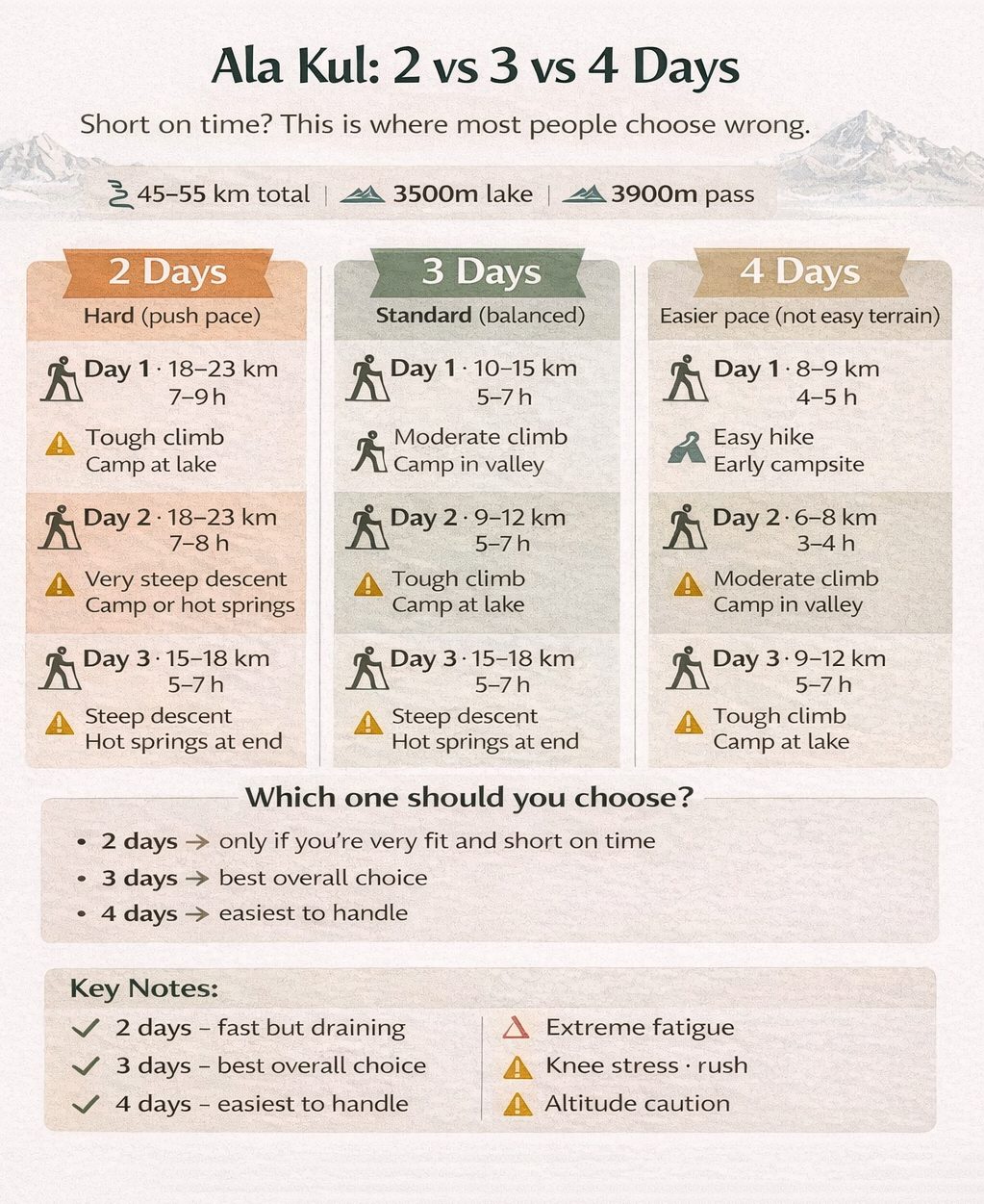
| Route Version | Best For | Main Trade-Off |
|---|---|---|
| 2 Days | Very strong hikers with limited time | Compressed effort, little margin for fatigue or weather |
| 3 Days | Balanced standard option for most travelers | Still demanding around the pass |
| 4 Days | Slower pacing, more recovery, more time to adjust to altitude | Requires more planning and extra time |
2 days feels like a push.
3 days feels like a route.
4 days feels like a landscape you actually move through.
The two-day version looks efficient from the outside. In practice, it turns the route into a push. You spend less time moving through the landscape and more time managing effort. It works, but it shifts the experience toward endurance rather than exploration.
Three days is where things start to settle into a more natural rhythm. The route still demands effort, especially around the pass, but you have enough space to recover between sections and actually notice where you are rather than just moving through it.
Four days changes the feel again.
The same terrain becomes less compressed. Breaks are longer, mornings start slower, and altitude has more time to adjust rather than building up in the background. Nothing about the route becomes easy, but it becomes more readable — less like a sequence you’re trying to get through, more like one you’re moving with.
There isn’t a single “correct” version.
But there is a clear difference between fitting the route into your schedule and letting the route set its own pace.
Planning Ala Kul Independently or With Support
This is usually framed as a simple choice — go on your own or go with a guide.
In practice, it’s more about how much of the route you want to manage yourself.
The terrain itself doesn’t force you into one option. The trail is generally clear enough, and many people complete it independently without issues. But the route isn’t only about navigation. It’s about pacing, altitude, overnight planning, and how much margin you want to carry.
Independent Trek
- Flexible pace — you adjust your movement day by day
- More control over stops, camps, and timing
- Lower overall cost if you already have gear
- A stronger sense of moving through the route on your own terms
Supported Approach
- Less planning pressure before and during the trek
- Clear structure for overnight stops and daily flow
- Extra margin in case conditions or energy levels shift
- Support with logistics, gear, or local knowledge if needed
What changes most between these options isn’t the route itself — it’s how much attention you need to give to everything around it.
When you go independently, the trek stays open. You decide when to stop, when to push, when to slow down. That flexibility can feel natural if you’re used to managing longer hikes.
With support, the structure tightens. Not in a restrictive way, but in a way that removes decisions. The route becomes more predictable, which can matter more than expected once altitude and fatigue start to build.
Neither approach is inherently better.
It depends on whether you want the route to remain something you actively manage — or something you can focus on moving through without thinking about every detail.
Best Time to Go to Ala Kul
The trekking window for Ala Kul is usually described in broad terms — summer, roughly mid-June to mid-September.
That’s accurate, but it doesn’t say much about how the route actually feels at different points within that window.
Weather at the lake and at the pass can feel like different seasons on the same day.
Warm valley start doesn’t translate to stable conditions at 3900m.
Early in the season, the landscape still carries traces of winter. Snow can remain on higher sections, especially near the pass. The route is quieter, but also less predictable. Conditions can shift quickly, and what looks manageable from below may feel different once you’re higher up.
Mid-summer — July into August — is when the route stabilizes.
The trail is clearer, snow is mostly gone from the main sections, and movement becomes more consistent. This is when the trek feels most “open,” in the sense that you can focus on the route itself rather than constantly adjusting to conditions.
Late season brings a different kind of shift.
The crowds thin out again, the light changes, and the landscape starts to feel quieter. At the same time, temperatures drop faster, especially in the evenings, and weather becomes less stable as autumn approaches.
The lake doesn’t change dramatically across these periods.
The pass does.
That’s the part that determines whether the route feels straightforward or uncertain. Snow, wind, and temperature swings all concentrate there, which is why timing matters more for the crossing than for the lake itself.
Ala Kul can look accessible across a wide season. The real question isn’t whether the lake is reachable — it’s whether the pass conditions make the route comfortable to cross.
Why Ala Kul and Altyn Arashan Belong in the Same Conversation
It’s easy to treat Ala Kul and Altyn Arashan as two separate highlights. One is a high alpine lake. The other is a valley known for hot springs and open space.
On a map, they look like different places.
On the ground, they behave like parts of the same movement.
The route doesn’t end at the lake. It doesn’t even peak there in a structural sense. The pass above Ala Kul pulls you forward, and once you cross it, the descent naturally leads into Altyn Arashan.
That transition is what gives the route its shape.
Up to the lake, everything builds — effort, altitude, focus. The terrain tightens, the path becomes more deliberate, and the environment feels increasingly defined by elevation rather than distance.
After the pass, that pressure starts to release.
The valley opens. Movement becomes less compressed. You’re still in the mountains, but the experience shifts from climbing and managing to moving and settling again. It’s not easier in a simple sense — just less concentrated.
Altyn Arashan amplifies that change.
Wide sections of valley, scattered structures, slower pacing, and the presence of hot springs create a contrast that feels almost out of proportion to how close it is to the pass.
That contrast is the point.
If you stop at Ala Kul and turn back, the route feels incomplete. You see the lake, you experience the climb, but you miss the release — the part where the terrain reshapes itself and the effort settles into something else.
Seen as a full sequence — Karakol Valley, the climb, the lake, the pass, and Altyn Arashan — the route reads differently. Less like a hike to a destination, more like a passage through two distinct mountain spaces.
That’s why the two names keep appearing together.
Practical Summary
Ala Kul isn’t difficult in the way people sometimes expect. It doesn’t require technical skills, and it doesn’t stretch out over extreme distances.
But it does ask for consistency.
The effort builds gradually, the altitude sits in the background, and the most demanding section arrives after you’ve already been moving for a while. There’s no single moment where the route becomes hard — just a steady shift where everything starts taking more energy than it did before.
That’s the part that matters most when deciding whether it’s the right route for you.
If you’re comfortable with multi-day movement, able to manage your pace, and willing to let the route unfold rather than rush through it, Ala Kul tends to work well. It rewards steady effort more than speed.
If you’re trying to fit it tightly into a schedule, or expecting a short approach to a single viewpoint, it can feel heavier than it looks.
The lake is what draws attention first. The pass is what defines the experience. And the descent into Altyn Arashan is what makes it feel complete.
Taken together, that sequence explains why this route holds its place among the most talked-about treks near Karakol — not because any single element dominates, but because all of them connect cleanly within a short stretch of mountains.
Ala Kul Trek in One Sentence
Ala Kul isn’t a hike to a lake — it’s a compressed mountain crossing where the lake sits in the middle, the pass defines the effort, and the descent into Altyn Arashan completes the route.
FAQ
How high is Ala Kul Lake?
Ala Kul sits at roughly 3500–3560 meters above sea level. The pass above it reaches closer to 3800–3900 meters, which is where altitude tends to feel more noticeable during the trek.
How difficult is the Ala Kul trek?
The route is usually considered moderate to difficult. Not because of technical terrain, but because of altitude, steady elevation gain, and how the hardest section aligns with the pass crossing.
Can you hike Ala Kul without a guide?
Yes, many travelers complete the trek independently. The route itself is generally clear, but planning, pacing, and managing altitude still require attention, especially on the pass day.
How many days do you need for Ala Kul?
Most people complete the route in three days. Two days is possible but more demanding, while four days allows for a slower pace and more time to adjust to altitude.
When is the best time to hike Ala Kul?
The main trekking window runs from mid-June to mid-September. July and August tend to offer the most stable conditions, especially for crossing the pass.
Is it better to combine Ala Kul with Altyn Arashan?
In most cases, yes. The route naturally continues into Altyn Arashan after the pass, and combining both creates a more complete and balanced experience of the region.